Geography
-
Id

- Posts: 82
- Joined: Wed Feb 16, 2005 9:53 pm
Geography
It seemed to me that the Grasslands were situated directly east of Dunan, or a little south east, but in Suikoden III there is Harmonian southern fringe troops in the very south of the Grasslands, and it seems that Tinto is even further south, I was wondering where exactly the grasslands fit in, because it looks like they changed it after suikoden II
-
The Black Knight

- Posts: 171
- Joined: Tue Feb 01, 2005 10:39 pm
- Location: Next to Luc, Sarah and Albert
- Contact:
The grasslands are situated sort of south east of Harmonia
And east of Dunan and Tinto.
Check it out in this map - http://www.suikox.com/geo/map.html
And east of Dunan and Tinto.
Check it out in this map - http://www.suikox.com/geo/map.html
What the Futch!!!!
Vagueness is my specialty.
Vagueness is my specialty.
-
SnowKing
- Posts: 151
- Joined: Mon Feb 14, 2005 3:47 am
-
True Wind Bearer

- Posts: 674
- Joined: Thu Feb 17, 2005 12:55 am
- Location: Australia
-
Vextor

- Global Admin
- Posts: 1875
- Joined: Sun Jun 27, 2004 2:45 am
- Location: Japan
- Contact:
You guys have your east/west screwed up. If Grassland is to the east, it would be in the ocean.
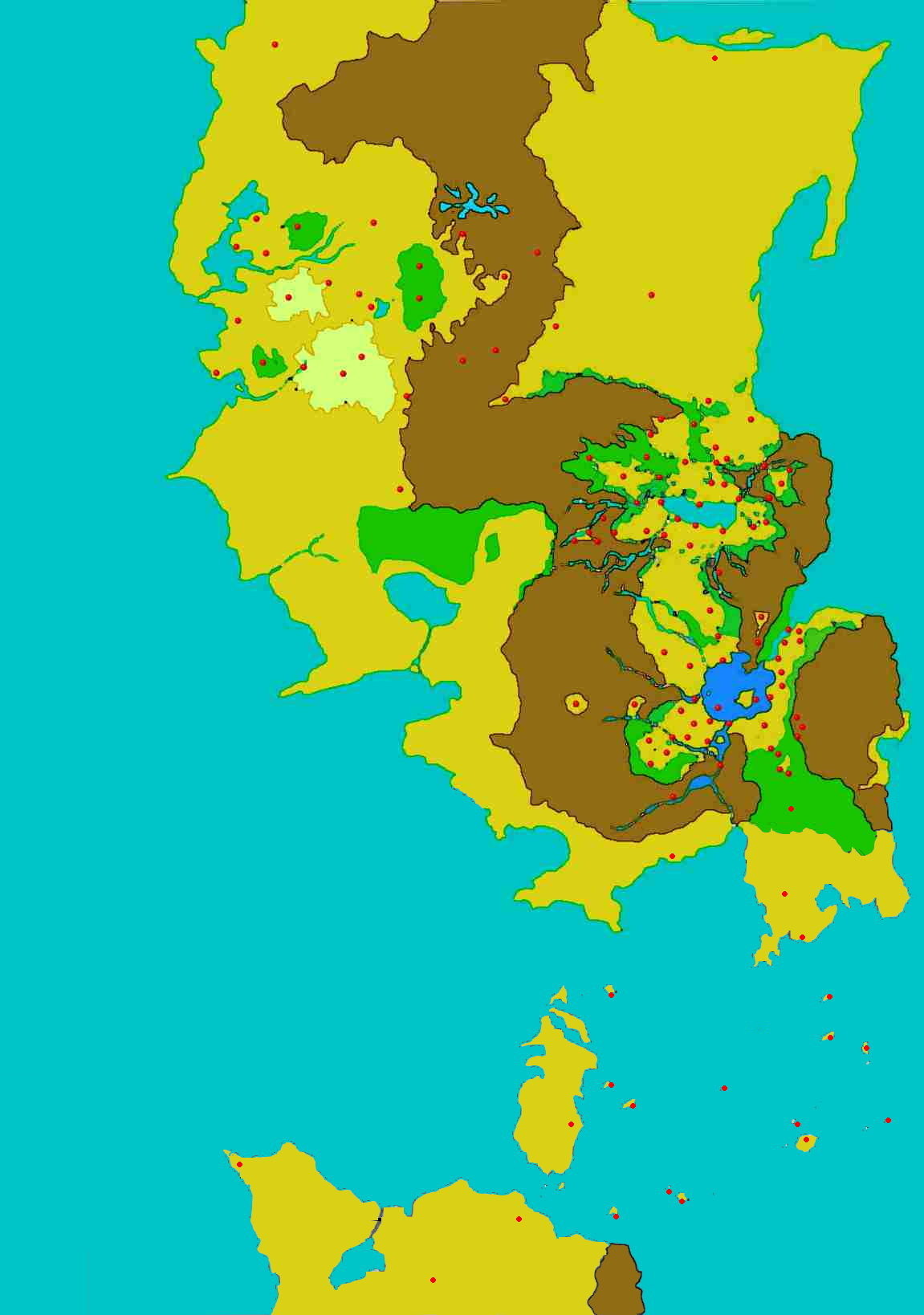
Konami has stated that Grassland is located west of Harmonia, while it is located northwest of Dunan. The map I drew for suikox.com is based on that information. Konami has also stated that the Kanakan region exists in the southern fringes of Toran, which still doesn't tell us where exactly it is located.
Konami has stated that Grassland is located west of Harmonia, while it is located northwest of Dunan. The map I drew for suikox.com is based on that information. Konami has also stated that the Kanakan region exists in the southern fringes of Toran, which still doesn't tell us where exactly it is located.
-
True Wind Bearer
- Posts: 674
- Joined: Thu Feb 17, 2005 12:55 am
- Location: Australia
LoL. I always get them mixed up, too.You guys have your east/west screwed up. If Grassland is to the east, it would be in the ocean.
Well done on that map, by the way, very good, I go to it for reference every time I get confused about the Geography of Suikoden. By the way, is the land of Suikoden called Suiko?The map I drew for suikox.com is based on that information.
-
Vextor
- Global Admin
- Posts: 1875
- Joined: Sun Jun 27, 2004 2:45 am
- Location: Japan
- Contact:
-
RageRune
- Posts: 281
- Joined: Sat Jun 26, 2004 9:01 pm
- Location: Michigan
Hey SARS I can ask if you're going to update that map to inculde the location of the Island Nations. I mean I know you got Island Nations down there, but like update the map to show the location of Obel,Na-Nal,Gaien,Razril,etc.
Anyway good job on the map. I always thought the Grasslands were Northwest too, since Tinto is to the south of it. And I guess you can't put Kooluk on there either since it is'nt known whether it still is a country or if it turned into the Southlands.
Anyway good job on the map. I always thought the Grasslands were Northwest too, since Tinto is to the south of it. And I guess you can't put Kooluk on there either since it is'nt known whether it still is a country or if it turned into the Southlands.
-
Vextor
- Global Admin
- Posts: 1875
- Joined: Sun Jun 27, 2004 2:45 am
- Location: Japan
- Contact:
Oh yeah, I never did update "that" map did I.
It's already done, but the imagemap itself is not complete yet.
You can see the picture itself in the following link, though.
http://suikox.com/geo/worldmap22.jpg
It's already done, but the imagemap itself is not complete yet.
You can see the picture itself in the following link, though.
http://suikox.com/geo/worldmap22.jpg
-
Vincent of Scarlet Moon
- Posts: 154
- Joined: Tue Mar 08, 2005 11:33 am
-
Vextor
- Global Admin
- Posts: 1875
- Joined: Sun Jun 27, 2004 2:45 am
- Location: Japan
- Contact:
-
True Wind Bearer
- Posts: 674
- Joined: Thu Feb 17, 2005 12:55 am
- Location: Australia
-
Vincent of Scarlet Moon
- Posts: 154
- Joined: Tue Mar 08, 2005 11:33 am