Hello Suikosource~
I hate to toss out a request as a first post, but Sars is quite busy lately and can't directly help me what what I need ^^;
This is primarially for anyone who has an import copy of Rhapsodia. I was wondering if there was a full map of the Kooluk region shown in Rhapsodia, like how maps of Island Nations, Toran, Grasslands and others have been shown in previous Suikoden titles.
The main reason I ask this is that I am making an updated version of the Suikoden World Map featured on Suikox.com. I have been making adjustments to the Island Nations area, and would like to take into account information from Suikoden Tactics as far as the official shape of the Kooluk region and the way it connects to Toran.
If anyone could assist me with this by means of a digital camera photograph or perhaps a magazine scan or screenshot I haven;t been able to find I would be greatly appreciative.
Thanks for your time.
Kooluk Map?
-
True Wind Bearer

- Posts: 674
- Joined: Thu Feb 17, 2005 12:55 am
- Location: Australia
-
Lucent
- Posts: 7
- Joined: Sat Nov 05, 2005 7:58 pm
Oh, well, that's a good heads up D:
Thanks for that.
Oh, and the map isn't just for Suikox, it's for any Suikoden site to use, really. It's going to not only be an update to their map but will incorporate an ""old world" style with navigation lines, a nice compass rose and other artistic details ^-^
Thanks for that.
Oh, and the map isn't just for Suikox, it's for any Suikoden site to use, really. It's going to not only be an update to their map but will incorporate an ""old world" style with navigation lines, a nice compass rose and other artistic details ^-^
Nothing to see here, move along.
-
True Wind Bearer
- Posts: 674
- Joined: Thu Feb 17, 2005 12:55 am
- Location: Australia
-
Vextor

- Global Admin
- Posts: 1867
- Joined: Sun Jun 27, 2004 2:45 am
- Location: Japan
- Contact:
-
Vextor
- Global Admin
- Posts: 1867
- Joined: Sun Jun 27, 2004 2:45 am
- Location: Japan
- Contact:
-
son_michael

- Posts: 2235
- Joined: Wed Feb 02, 2005 12:24 am
- Location: New York
-
Lucent
- Posts: 7
- Joined: Sat Nov 05, 2005 7:58 pm
Version 1 of the world map
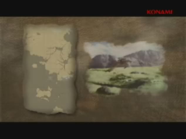
Based on continental information that was snuck to us through some new Suikoden V videos that show a map of the known suikoden world I made this composite. Mind you there is about 20% conjecture on mountains and coastlines in the map and it is an amalgamation of the "game map" from Suikox.com and the canon maps found throughout the game.
Since I discussed this some time ago I thought I would show progress. This is not what the final product will look like, which will be more fashioned to resemble a cartographical chart (sans mountains) with navigation lines, compass rose etc. This was just a test of the map layout to see what I could do.
The map is public domain if you wish to use it for whatever purposes, just toss a line of credit or two my way (and let me know you're using it so I can see it~) if you decide to for whatever reasons.
The map is based off of the map from a recent Suikoden V video material (see below)
http://i31.photobucket.com/albums/c379/ ... cap138.jpg
In a few weeks I'll get started on the cartographical version of the map, but for now enjoy this sample of things to come.
Edit by Oppenheimer: IMG tags are not allowed, only links to images. Thanks.
-
Oppenheimer
- Global Admin
- Posts: 2861
- Joined: Tue Mar 15, 2005 10:41 am
- Location: ON, Canada

-
Lucent
- Posts: 7
- Joined: Sat Nov 05, 2005 7:58 pm